WHERE SPRINGS RUN COLD: COLD SPRINGS TRAIL, CALIFORNIA
California: Dream of many outdoor explorer, hiker and nomad. Its diverse fauna, countless trails and loads of Vitamin D make the state in the Southwest of the US a popular destination for many. Everything is bigger in the United States – and so are the distances of many accommodations to the trails. That did not keep me from trying to get to an abandoned and gorgeous outlook in the South: Montecito Peak.
TRAVELHIKINGFULL DAY
Vanessa
1/12/2016
California: Dream of many outdoor explorer, hiker and nomad. Its diverse fauna, countless trails and loads of Vitamin D make the state in the Southwest of the US a popular destination for many. Everything is bigger in the United States – and so are the distances of many accommodations to the trails. That did not keep me from trying to get to an abandoned and gorgeous outlook in the South: Montecito Peak.
"You need a car to get there"
"You need a car to get there," the receptionist spoke. I had just wanted to double-check the directions to the Cold Springs trail head and must have looked bedazzled at his response. "But... It says it's only about 45 minutes of a walk from here and I can see the hills from the window," I replied slightly confused, pointing to the hills towering above the hostel that I had spent the night at. The receptionist stuck with his first response. Accepting defeat, however, was not on my agenda for the day. And so I set out with my directions I had gotten from the internet, hoping Google would not let me down.
Walking up a rather steep area that is surrounded by modern family houses and a vineyard, I surpass a school, where the bells have just rang for lunch. Right after the educational institution I can see the asphalt streets changing into a gravelly trail. Behind them, Santa Ynez mountains are towering over the area. The Mountain Range builds the border between the inland and the ocean. Following the street into a curve, I suddenly spot what I had hoped to find: The Trail Head of Cold Springs Trail. It had taken me exactly 42 minutes to get there.
NOW FOR THE REAL CHALLENGE
Entering the woods of Cold Springs is almost as if I am entering a whole new world. It is as though I have escaped civilization and am diving right into wonderland. Mossy pathways lead me along fir trees and a small stream. The trail eventually turns into the thick forest, which provides the shade I desperately need in California's midday sun.
Even in the winter months, Southern California's temperature rarely drop under 4 Degrees Celsius. That makes for great hiking weather, while the northern hemisphere of the world is shivering in the cold.
Back on the trail I pass a massive, old willow tree. From there, the trail begins to incline slightly and winds its way up to the peak that I am intending on reaching. The path does not get steep, though, and makes for a leisurely walk that burns a calorie or two. All the while, I am surrounded by gorgeous, old pine trees that reach high up into the blue, oh, so blue sky.
I follow the – only – trail and only encounter two other guys hiking up towards the place I intend on reaching: Montecito Peak. It is about 40 minutes later and a few meters higher above sea level, when I leave the shady forest behind and I reach my goal I set for lunch break.
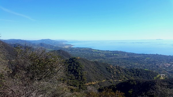
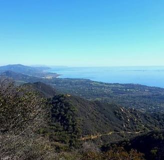
My calculations turn out to be right; it is 2pm now and I feast on a delicious Quinoa salad, as I overlook the shores of Santa Barbara. Looking to the left, I realize it is not only Santa Barbara's bay that sprawls out before me; I almost feel like I am able to spy all the way to Ventura. Well rested and with my head full of gorgeous pictures, I continue my hike, attempting to make it up to the Cold Spring Saddle. My trail from here on is gravel on dried out soil, proving that Southern California is suffering from a water crisis.
An even bigger reminder is the sign that I come across shortly after climbing the first hills. "Closed due to wildfires" is what brings my hike to an abrupt – early – end. As a consequence, I did sadly not reach my end goal of reaching San Ysidro Falls, but I shall be back and hike it all soon enough (hopefully)!
In the meantime, I enjoy the stunning views from up here that make the climb absolutely worth it!
Have you, by any chance, done the full hike? Did you make it to San Ysidro Falls? How was your experience? I want to hear all about it!
HIKE INFORMATION
Difficulty: Medium
Duration: Approx. 5-6 hours (incl. way to trail and back)
Starting Point: Santa Barbara, East Side
Ending Point: Santa Barbara, Waterfront
Gear: Hiking boots or boots with a very good profile, 2-3 liters water bottle, sun screen and sun glasses, Hat
Route: Santa Barbara East Side - Eucalyptus Hill - Hale Park - Lotusland - Cold Springs Trail Head - Gould Park - Montecito Peak - Cold Spring Saddle
Caution: Parts of this trail are along a street that is accessible for cars. If you feel unsafe hiking near a street with cars, I suggest renting a car and driving to the Cold Spring trail. Stay safe!